
Archived GIS Snippets
Published in 2013
Permanent URL
University of Massachusetts Boston Honors Esri President

Jack Dangermond, founder and president of Esri, was presented with an honorary Doctor of Science degree at the University of Massachusetts, Boston’s commencement ceremonies on May 31, 2013.
A landscape architect by training, Dangermond is one of the world’s pioneers in the creation and practice of geographic information systems (GIS); technology used for managing, analyzing, and sharing location-based information for better decision making.
Dangermond founded Esri in 1969 in Redlands, California. The company is widely recognized as the technical and market leader in GIS, developing innovative solutions for working with spatial data on the desktop, across the enterprise, in the field, on the Web, and within the cloud.
He is recognized not only as a pioneer in spatial analysis methods but also as one of the most influential people in GIS. Dangermond is personally committed to applying GIS methods for environmental stewardship and sustainable communities.
“We are honored to recognize Jack Dangermond,” UMass Boston Chancellor J. Keith Motley said. “His innovation, persistence, and vision have created nearly infinite uses for GIS technology, improving the quality of life for people around the world.”
Dangermond graduated with a Bachelor of Science degree in landscape architecture from California State Polytechnic University, Pomona. He holds a Master of Architecture degree, with a focus on landscape architecture and urban planning, from the Institute of Technology at the University of Minnesota and a Master of Science degree in landscape architecture from the Graduate School of Design, Harvard University.
He holds honorary doctorates from the University of Minnesota, Minneapolis; California State Polytechnic University, Pomona; State University of New York, Buffalo; University of West Hungary; City University London; University of Redlands, California; Loma Linda University, California; Technical University for Civil Engineering of Bucharest; University of Arizona, Tucson; and Ferris State University, Michigan.
Dangermond has received a number of awards including the Alexander Graham Bell Medal from the National Geographic Society (2010), Patron's Medal from the Royal Geographical Society (2010), Public-Private Partnership Award from the National Governors Association (2009), Carl Mannerfelt Medal from the International Cartographic Association (2008), and the Henry Shaw Medal from the Missouri Botanical Garden (2006).
UMass Boston has a well-established GIS curriculum that supports programs in its College of Science and Mathematics, McCormack Graduate School of Policy and Global Studies, Andrew Fiske Memorial Center for Archaeological Research, and the Urban Harbors Institute. Through the School for the Environment, UMass Boston offers a Geographic Information Technologies certificate that was established by Dr. Zong-Guo Xia, current Vice Provost at the University. The program is a leader in the region, supplying GIS professionals for municipal, state and federal agencies, as well as teachers and researchers worldwide.
first published week of: 06/10/2013
Permanent URL
UNO will develop map systems for the Navy

The University of New Orleans Department of Computer Science has been awarded a 5-year $663,000 research contract by the Naval Research Laboratory to develop next-generation defense mapping systems. The principal investigators on the project are Mahdi Abdelguerfi, professor and chair of computer science, and John Finigan, IT director of the computer science department.
The project builds upon UNO's existing expertise in geospatial mapping systems, which refers to various types of map data including satellite photos, sea floor depth, land elevation and roads, according to Abdelguerfi.
The project is expected to use open-source software and commodity hardware—meaning hardware that is relatively affordable and generally compatible with other such devices—that will enable the Navy to process more map data faster and more cost effectively than the legacy systems that a lot of agencies are using, Abdelguerfi said.
first published week of: 11/11/2013
Permanent URL
Untold Tale Behind USS Guardian Reef Grounding: NGA’s Map Was Wrong By 8 Miles
by colin clark
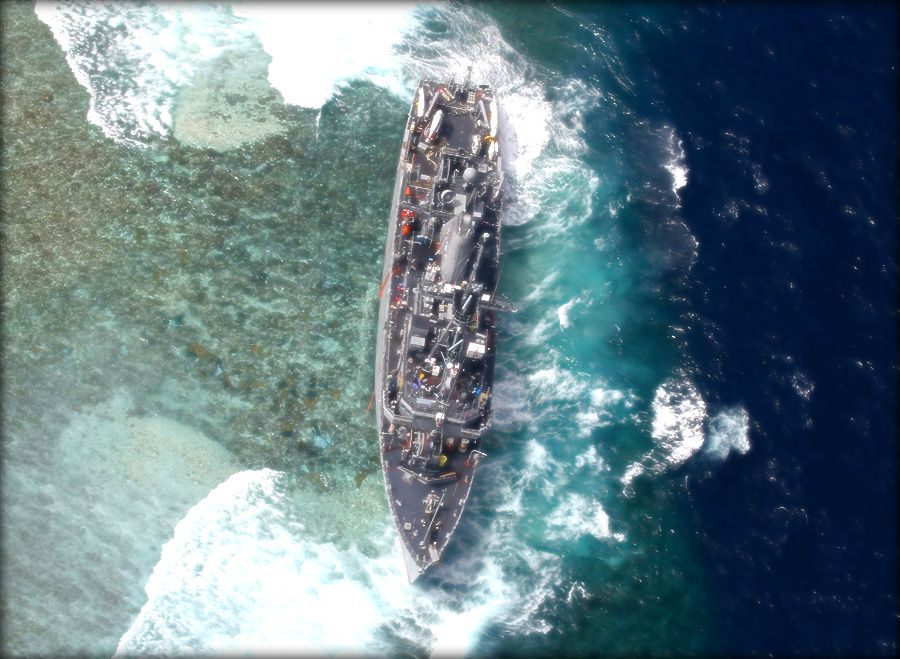 USS Guardian lies crippled on UNESCO World Heritage Tubbataha Reef in the Philippines
The January grounding of the minesweeper USS Guardian in a Philippine coral reef was caused in large part by a National Geospatial Intelligence Agency (NGA) map that was, quite simply, wrong by eight nautical miles, Breaking Defense has learned.
“It really was just a terrible fluke that caused the error,” NGA spokeswoman Christine Phillips said in a frank discussion of the incident and its aftermath.
The Sulu Sea grounding prompted NGA to order an agency-wide review of the nautical charts detailing the entire surface of the earth covered by the oceans. Also, NGA and the Navy have convened a team of maritime experts to take “an exhaustive look to make sure we are as sound as we can be,” Phillips told me.
The error boiled down to someone at NGA failing to update a map with corrected data after cartographers discovered an inaccuracy.
Here’s what happened. “Prior to 2008, charts in that area included many ‘phantom’ reefs and islands — legacies of old maps and data. In response to customer requests to remove these, NGA used LANDSAT-derived commercial imagery to update the charts,” Phillips said, noting the commercial data was the only information source available for that area. The Landsat data was wrong. continued…
first published week of: 07/29/2013
Permanent URL
US ARMY seeks GPS replacement
In a bid to limit its dependence on GPS, the US Army has joined forces with DARPA (Defense Advanced Research Projects Agency) in order to develop the next generation of navigation technology. The emerging solution is much smaller than current instruments used today. So small in fact, it can fit comfortably on the face of a penny.
According to DARPA – the driving force behind the creation of the Global Positioning System, “sometimes a capability is so powerful that our reliance on it, in itself, becomes a vulnerability.” Case in point: navigation signals were recently scrambled in South Korea by the North, who actively employ a GPS Jammer Brigade.
To that end, researchers at DARPA and the University of Michigan have developed a new system. Able to determine position, time and direction, the new technology is contained within an eight-cubic-millimeter chip.
first published week of: 04/29/2013
Permanent URL
Use Bing Maps for Windows Store apps
by andrea boschin
Since the birth of Google Maps in early 2005, the mapping systems have grown significantly and become part of the business in different ways. There are plenty of opportunities in connecting today's modern devices, equipped with GPS sensors, together with maps and it is the reason because Bing has continuously delivered new versions of its own mapping controls, from the web version to Silverlight and finally for the Windows Store apps.
This new release comes in a separate download that can be easily found using the Visual Studio's extension manager, but it requires some kind of attention given its nature of a C++ component. continued…
first published week of: 03/18/2013
Permanent URL
Use Bing Maps for Windows Store apps
by andrea boschin
http://www.silverlightshow.net
Since the birth of Google Maps in early 2005, the mapping systems have grown significantly and become part of the business in different ways. There are plenty of opportunities in connecting today's modern devices, equipped with GPS sensors, together with maps and it is the reason because Bing has continuously delivered new versions of its own mapping controls, from the web version to Silverlight and finally for the Windows Store apps.
This new release comes in a separate download that can be easily found using the Visual Studio's extension manager, but it requires some kind of attention given its nature of a C++ component. continued…
first published week of: 03/25/2013


 ♦
♦ 