
Archived GIS Snippets
Published in 2013
Permanent URL
Shortcut To Uploading Photos To Your Google Maps Business Listing
by barry schwartz
Jade Wang from Google gave a tip in a Google Business Help thread on how to expedite the uploading and listing of photos on your Google Business Maps listing page. Typically, a business owner would upload photos through managing their page within Google+ or via Google Places. But that process can take a month for the photos to be approved and visible within Google's search results and Google Maps.
Instead, Jade said you can take a "shortcut" by uploading the photos by going to the Photos tab of the Google+ Local listing. continued…
first published week of: 02/18/2013
Permanent URL
Silliest Maps of the Week
Population dot maps have become very popular over the last few months.
Usually these maps are created using data gathered from national
censuses.
Tyler Olson however has decided to build his dot map of the world from
the ground up. And you can help. All you have to do is visit Yapmap
and a dot at your location will automatically be added to the map. The
more people who visit the map then the better this dot map of the world
will become.
Even with only a few visitors Yapmap is beginning to take shape. I can
already make out north America and Western Europe on the map. If you are
reading this then please visit Yapmap as I'm really keen to find out
what the map will look like once it has had a few thousand visitors.
first published week of: 11/11/2013
Permanent URL
Skobbler debuts ForeverMap 2 for iOS, an OpenStreetMaps-powered mapping tool with offline route-planning
by paul sawers
There’s no shortage of mapping and GPS apps for iOS, and in the fallout from Apple Maps’ disastrous launch last year, the spotlight was shone on a number of mapping alternatives. And Google Maps finally arrived on the scene too.
But one of the others ones out there, built on OpenStreetMap – the user-generated, collaborative project that’s striving to produce editable maps of the world – is Skobbler‘s ForeverMap, which we first looked at way back in March 2011.
In a nutshell, ForeverMap lets users input an address to receive a range of directions depending on their method of transportation; walking or driving. The map is able to follow your position using GPS, and it also has an offline mode giving you access to maps which are downloaded while you have a connection.
Now, Skobbler has launched ForeverMap 2 – essentially ForeverMap 3.0 sporting a different name – with a slew of new updates. continued…
first published week of: 05/06/2013
Permanent URL
So you want to make a map…
by noah veltman
Just because something can be represented geographically doesn’t mean it should. The relevant story may have nothing to do with geography. Maps have biases. Maps can be misleading. They may emphasize land area in a way that obscures population density, or show “geographic” patterns that merely demonstrate an underlying demographic pattern. Before you proceed, make sure a map is what you actually want.
Maps generally consist of geographic data (we’ll call this geodata for short) and a system for visually representing that data.
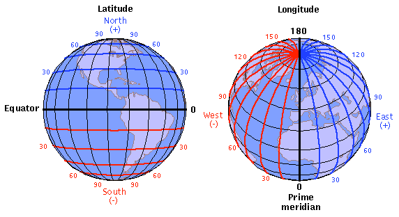
Latitude and Longitude
Most geodata you encounter is based on latitude/longitude coordinates on Earth’s surface (mapping Mars is beyond the scope of this primer).Latitude ranges from -90 (the South Pole) to 90 (the North Pole), with 0 being the equator.Longitude ranges from -180 (halfway around the world going west from the prime meridian) to 180 (halfway around the world going east from the prime meridian), with 0 being the prime meridian. Yes, that means -180 and 180 are the same.
first published week of: 11/11/2013
Permanent URL
Space and Time Come Together Through Esri and OSIsoft Partnership
OSIsoft, producer of the PI System, the leading operational data infrastructure for real-time data and events, and Esri, the global leader in geographic information systems (GIS), today announced a strategic partnership to execute on the vision of Real-time GIS.
"Maps are a fundamental way in which we communicate information. They tell us where things are. By bringing together ArcGIS and the PI System, customers will not only know where things are but what they are doing in real-time," says Jack Dangermond, President of Esri. "By displaying real-time and historical information on a map, our customers will unlock opportunities in their data not previously visible."
OSIsoft and Esri aim to bring out of the box integration between the PI System and ArcGIS, enabling a platform for real-time GIS as well as seamless back-office integration between operational data management and GIS.
"This partnership will bring significant value to our mutual customers, allowing them to visualize and analyze their operations geographically in real-time at unprecedented levels of detail and scale," says Dr. J. Patrick Kennedy, CEO and Founder of OSIsoft. "Adding a geospatial dimension to OSIsoft's data and events management infrastructure has applications across all our industries. We're really excited about the possibilities this partnership will enable in smart grid, energy management, clean tech, and transportation."
Both technologies leverage Windows Azure, Microsoft's cloud platform, enabling a wide range of secure deployment options on premises and in the cloud.
first published week of: 04/22/2013
Permanent URL
Spatial Energy Introduces TapSpatial Mobile Geospatial App for iPad
Spatial Energy, a provider of geospatial solutions to the worldwide energy industry, today introduced the TapSpatial mobile app for the iPad. Designed with oil and gas professionals in mind, TapSpatial allows iPad users to access a global imagery base map, import other spatial data content, and mash up layers into custom maps they can take into the field for offline use.
Available for free at the Apple App Store, TapSpatial includes access to an up-to-date, high-resolution image data layer covering the entire world. Additionally, iPad users can tap directly into their own proprietary enterprise data service or spatial content from other web sources, including Esri, Bing Maps, and Google Maps. Users may also purchase a subscription to access premium Spatial Energy content, such as Digital Elevation Models, bathymetry, land grid, well locations and a variety of remote sensing imagery.
“We created the TapSpatial mobile app so that energy professionals can download their customized spatial data and take it out of the office into the field,” said Bud Pope, Spatial Energy President. “Online or offline, TapSpatial lets end users maximize the value of their spatial data by putting it to use at any time wherever they are.”
TapSpatial users are able to integrate multiple spatial data layers and toggle specific layers on or off, while also zooming and panning on the iPad touchscreen. The built-in iPad GPS allows for live map navigation and coordinate display. Spatial Energy has developed energy-specific mark-up tools for onscreen annotation and drawing points, lines and polygons. Customized map layers can be emailed with attached photos and notes from the field. Offline caching capacity allows users to work on multi-layer data sets in the field when web access is unavailable. For more information on what data layers and subscriptions are available for TapSpatial, go to the website at www.tapspatial.com.
“TapSpatial differs from other apps in that it allows iPad users to aggregate their internal company geospatial data layers with data from external sources to create unique maps in the field or in the office,” said Pope.
For subscribers to the Spatial on Demand® service, TapSpatial is a direct mobile portal into Spatial Energy’s popular spatial data management and delivery system. Designed to provide enterprise access to raster imagery and mapping data for global energy organizations, Spatial on Demand eliminates data archiving and maintenance challenges by hosting the subscriber’s legacy data sets on Spatial Energy’s secure servers. TapSpatial users can view, select and download data from their Spatial on Demand database. For information on an enterprise license and specific data layers in TapSpatial with Spatial on Demand, please email tapspatial@spatialenergy.com or visit the Spatial Energy website.
To create the TapSpatial mobile app, Spatial Energy teamed with NeoTreks Inc. of Monument, Colorado. NeoTreks is an award-winning developer of geospatial apps for the iPad, iPhone and other tablet platforms. Spatial Energy also offers custom development options based on the TapSpatial application through NeoTreks.
Watch the Introduction to TapSpatial video to learn more.
first published week of: 03/04/2013


 ♦
♦ 