
Follow
Blog: Chris Harlow on ITISSN 0742-468X
Since 1978
On-line Since
Y2K
Search The Harlow Report Archives

Custom Search
menu
Archived GIS Snippets
Published in 2019
Permanent URL
Apple Secretly Working on Satellite Technology for iPhones
by Jibran Ahmed
Apple is reportedly working on a satellite technology that will render wireless coverage and connectivity to its hallmark iPhone mobile devices. This new ambitious venture by Apple will dramatically improvise the iPhone’s security and location-based services. The new satellite project, if succeeds, will make iPhone the world’s first mobile device that will no longer dependent on carrier service providers to make calls or connect to the web. The satellite tech on which Apple is working will take care of this. Pretty amazing, right?
If we are to believe this report, Apple has already gotten into action and has built a team of a dozen or more top engineers from satellite, aerospace, and antenna niches, respectively. The goal of the California-based tech giant is to develop a working satellite framework for the iPhones within a span of five years, sources inside the company mentioned on anonymity condition, as reported in an article on Bloomberg. However, it is also noted that the project is in its primitive condition, and if initial results could not meet the expectations, this ambitious project can be shelved for the right time.
Apple Chief Executive Officer Tim Cook is said to be showing a keen interest in this new and ambitious satellite technology for iPhones.
Read full story at Tunf…
first published week of: 12/30/2019
Permanent URL
ArcGIS Earth Mobile 1.0 is Released
by Jasmine Du
With more than 50,000 beta testers from both Android and iOS, the ArcGIS Earth team is excited to announce that ArcGIS Earth Mobile 1.0 is now available in both Google Play and the App Store!
ArcGIS Earth Mobile introduces 3 methods to add data – Add data from Portal Content, Add local files, and Add data by Url. ArcGIS Earth Mobile is capable of browsing GIS content both online and offline. When connected with a network, you can add web scenes, map services, image services, scene services, and feature services. You can also browse rich content provided in the Living Atlas. ArcGIS Earth Mobile supports intermittent connectivity usage by allowing you to add local files including mobile scene packages (MSPK), KML, KMZ, tile packages and scene layer packages (SLPK).
Read full story at ArcGIS Blog…
first published week of: 09/30/2019
Permanent URL
Are You a Linear or Are You a Looper?
by Jocelyn
One of the most popular ‘looped routes’ in Great Britain: the Pyg Track ascent of The Snowdon Horseshoe.
Do you prefer to keep to the straight and narrow? Or are you the type that goes around in circles?
Our Graduate Consultant Data Scientist, Jacob Rainbow, has conducted an analysis on the walking preferences of OS Maps app users.
One interesting aspect he has discovered is that there is an almost fifty-fifty split in the publicly available routes across Great Britain that can be walked in a day (25km or less). Of the 150,000 ‘returning’ routes that qualified under Jacob’s criteria, 46% are linear. This means they are ‘there and back’ walks, where people retrace their steps along the same path and cover the same ground.
Whereas the other 54% of routes are of a more looped nature. These are the walks where you feel like you’re constantly moving forward, seeing new things and eventually find yourself back where you started.
Read full story at Ordnance Survey…
first published week of: 07/15/2019
Permanent URL
Argonne National Lab's Emily Zvolanek Discusses Geographic System
by COD Newsroom Patch Contributor
Argonne National Lab's Emily Zvolanek Discusses Geographic Information Systems at Free COD STEMinar Feb. 13, 2019
Learn how researchers capture, manipulate and analyze geographic data during "The Power Behind Maps: Geographic Information Systems" at 4 p.m. on Wednesday, Feb. 13, in the Health and Science Center, Room 1234, on the College's Glen Ellyn campus, 425 Fawell Blvd.
The event, part of the College's STEMinar series, is free and open to the public.
Zvolanek will discuss GIS, a set of tools and skills that connect geographical features with tabular data allow people to analyze spatial data and extract useful information, the ways it is used in everyday life, and her work applying GIS to environmental science at Argonne National Lab.
A senior GIS analyst at Argonne's Environmental Science Division, Zvolanek's specialties include cartography, python programming for GIS, and the application of geospatial methods to environmental, cultural, visual, and socioeconomic analyses. She earned a bachelor's degree in environmental science from Monmouth College and a master's degree in GIS from the University of Washington.
Read full story at Patch…
first published week of: 01/21/2019
Permanent URL
Arkansas' Governor Touts Benefits of $1.2 Million Mapping Effort
by bill bowden and emilywalkenhorst
Madison County sheriff’s office Sgt. Lola Mitchell on Wednesday in Huntsville shows Gov. Asa Hutchinson how the digital mapping program will help with law enforcement and emergency calls.
( Bill Bowden )
For 19 days in January and February, five airplanes flew 19,000 feet above Arkansas, shooting 30,066 digital images of the entire state's terrain.
Those images, which encoded latitudinal and longitudinal coordinates, have been woven into a detailed digital map of the state.
Gov. Asa Hutchinson announced completion of the yearlong, $1.2 million mapping project Wednesday in the hallway of the Madison County Courthouse in Huntsville.
He said the benefits are at least two-pronged: Emergency responders will have more up-to-date information, and accurate digital mapping is essential for economic development.
"The face of Arkansas is changing rapidly," Hutchinson said in a news release. "Counties all over the state are building new roads, widening existing highways, adding businesses, homes and developing entirely new neighborhoods. Having an up-to-date detailed map of our state is a key tool for economic development and expanding infrastructure as our state continues to grow."
"If we do not have accurate information, then we're not going to be competitive in economic development," Hutchinson said during the news conference.
Read full story at Northwest Arkansas Democrat Gazette…
first published week of: 07/08/2019
Permanent URL
Army Photogrammetry Technique Makes 3D Aerial Maps in Minutes
by devin coldewey
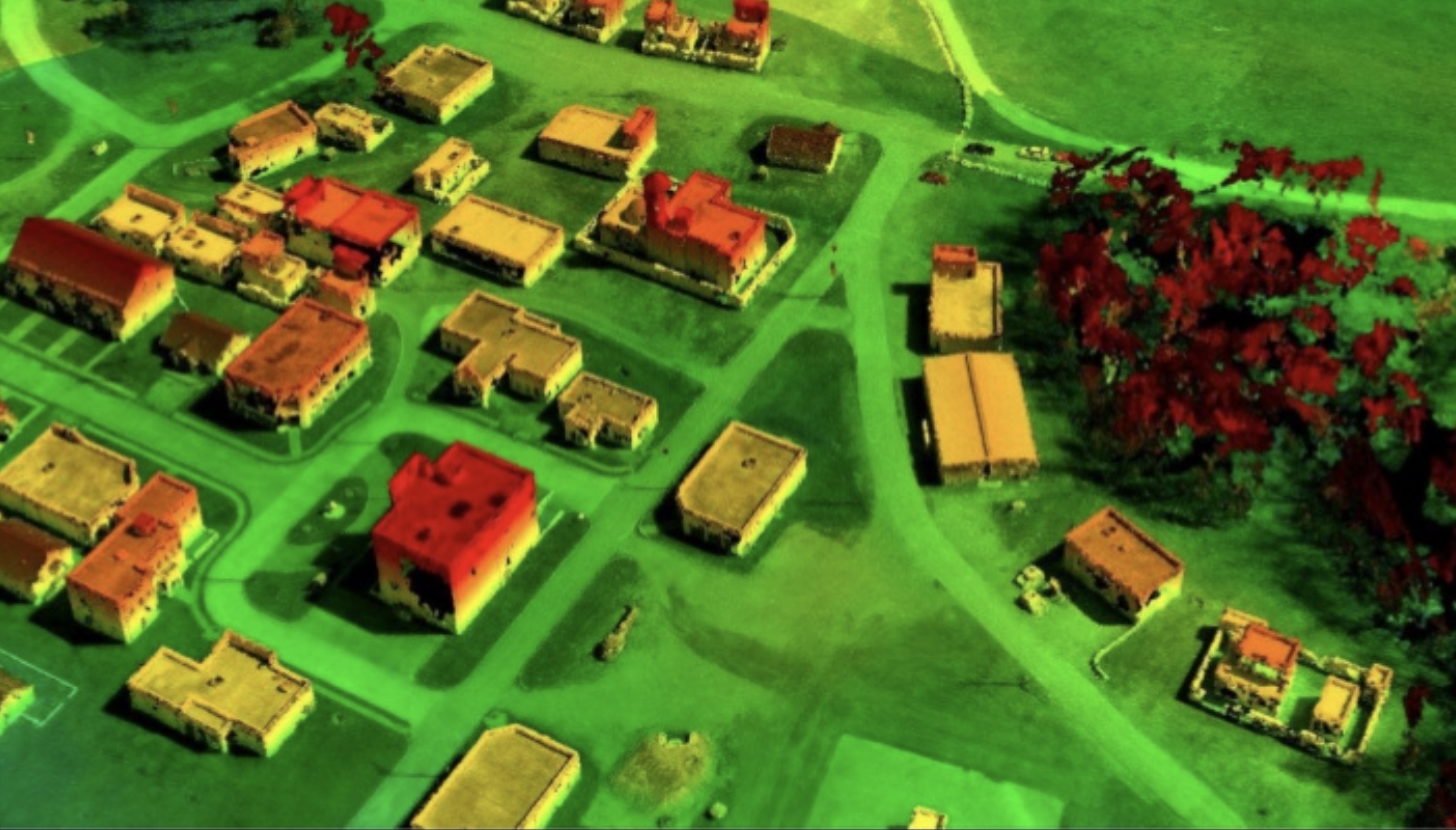
This image shows the depth map as color – red being higher. It was created from combining multiple 2D images.
Aerial imagery is a common asset in military matters, but 3D maps can be difficult to collect on short notice without specialized equipment. This new photogrammetry technique from the Army Corps of Engineers, however, can make accurate 3D maps from ordinary aerial footage in just minutes. Photogrammetry is the process of comparing multiple photos of the same location or item to produce a 3D map of it. It’s a well-known method but in some cases is still reliable on human intelligence to determine, for instance, which frames of a video should be used to produce the best results. Ricky Massaro from the Army’s Geospatial Research Laboratory in Virginia has mitigated that problem and produced a highly efficient photogrammetric method that can turn aerial imagery into accurate 3D surface maps in near real-time without any human oversight. The system was tested by the 101st Airborne, which flew a drone over Fort Campbell in Kentucky and mapped a mock city used for training exercises. It was also deployed in Iraq for non-combat purposes. So this isn’t stuck in a lab somewhere — it’s been put to work, and is now being publicized because the patent filing is in and the Army is now negotiating to commercialize the system.
Read full story at TechCrunch…
first published week of: 11/18/2019
 ♦
♦ 