
Follow
Blog: Chris Harlow on ITISSN 0742-468X
Since 1978
On-line Since
Y2K
Search The Harlow Report Archives

Custom Search
menu
Archived GIS Snippets
Published in 2019
Permanent URL
Why Operational Dashboards Are Vital for Emergency Management
by Liam O’Brien
This web-based model dashboard is hosted by Esri ArcGIS Online. It provides locational and tabular data on rescue requests, rescues completed, the status of rescue workers, and the status of hospitals and shelters.
In today’s tech-driven society, nearly every person and every device has the potential to share location-based data in near-real time with a global audience. For example, individuals can send location-tagged images via smartphones; post real-time events on Twitter; contribute data to crowdsourcing applications such as the traffic and navigation app, Waze; and post information about their location from internet-enabled fitness bands and smartwatches.
Much of this data is used by public safety and emergency management agencies. For example, the movement of buses, trains, aircraft, and first responder vehicles can be tracked, and traffic incidents and road conditions monitored. People needing rescue in disaster incidents can request help using smartphones, and rescue personnel can continuously update their location and status to Emergency Operations Centers. During an emergency response, critical supplies and materials can all be tracked and monitored. There is no slowing down in the increasing scope and sources to transmit near real-time, location-based data.
How Location-Based Data Helps Emergency Managers
The application of this technology and the shared data holds immense potential for those with emergency management responsibilities. Emergency managers currently rely on a wide variety of location-based data to support their mitigation, preparedness, response, and recovery missions. However, it can be a daunting task to figure out how to effectively turn the overwhelming flood of raw data into usable information that can be analyzed and shared.
Read full story at In Public Safety…
first published week of: 06/24/2019
Permanent URL
Wireless Carriers Caught Playing Fast and Loose With Location Data
by Richard Adhikari
AT&T, T-Mobile and Sprint have sold access to subscribers' real-time location data to aggregators, which in turn have sold it to about 250 bounty hunters and related businesses, Motherboard reported Wednesday.
In some cases, the data allowed users to track individuals to their specific locations inside a building.
Some companies made thousands of location requests to data brokers; one company made more than 18,000 such requests in just over a year.
The news, which sparked widespread outrage, prompted a range of responses, including the following:
Read full story at TechNewsWorld…
first published week of: 02/11/2019
Permanent URL
Wireless Carriers Caught Playing Fast and Loose With Location Data
by Richard Adhikari
AT&T, T-Mobile and Sprint have sold access to subscribers' real-time location data to aggregators, which in turn have sold it to about 250 bounty hunters and related businesses, Motherboard reported Wednesday.
AT&T, T-Mobile and Sprint have sold access to subscribers' real-time location data to aggregators, which in turn have sold it to about 250 bounty hunters and related businesses, Motherboard reported Wednesday.
In some cases, the data allowed users to track individuals to their specific locations inside a building.
Some companies made thousands of location requests to data brokers; one company made more than 18,000 such requests in just over a year.
The news, which sparked widespread outrage, prompted a range of responses, including the following:
Read full story at TechNewsWorld…
first published week of: 03/25/2019
Permanent URL
With New Mapping Workflow, Trimble Extends the
Reach of GNSS with LTI Laser Rangefinders
by Trimble Press Release
Remote Feature Capture in Trimble TerraFlex Software Increases Productivity and Safety for GIS Mobile Workers
Trimble announced tits Trimble® TerraFlex™ field software now supports remote feature capture with Laser Technology, Inc. (LTI) TruPulse® 200 series and 360° series laser rangefinders. The solution enables easy, accurate and safe capture of Geographic Information System (GIS) features in locations that are physically inaccessible, hazardous and in challenging Global Navigation Satellite System (GNSS) environments.
"Assets in places such as a busy roadway or under dense tree canopy can make it difficult for users to capture location information accurately, safely and efficiently," said Derrick Reish, senior product manager at LTI. "The TruPulse series laser rangefinders enable users to accurately measure these assets without having to physically occupy the location."
The new TerraFlex feature extends the reach of Trimble GNSS solutions when paired with the TruPulse laser rangefinders. These include the Trimble TDC150 high-accuracy GNSS handheld or the Trimble TDC600 handheld running the Trimble Catalyst™ on demand positioning service.
"Embedding this functionality directly into the TerraFlex app simplifies the offset mapping workflow and enables users to accurately capture features in more places," said Rachel Blair-Winkler, business area manager for Trimble Mapping & GIS Solutions. "This release represents the continuation of Trimble and LTI working together to support laser rangefinder technology in Trimble GIS software solutions."
Trimble TerraFlex is available online at geospatial.trimble.com/terraflex or through Trimble's Authorized Geospatial Distribution channel. LTI TruPulse 200 series and 360 series laser rangefinders are available through LTI's authorized dealer channel. For more information, visit: www.lasertech.com/TruPulse-Laser-Rangefinder.
Read full story at Trimble…
first published week of: 12/16/2019
Permanent URL
XPRIZE Partners with Esri on Ocean Mapping Challenge
by dawn wright
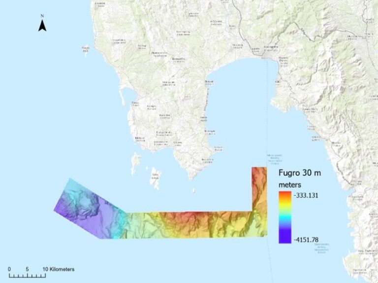
Prior to the final trial, XPRIZE contracted with Fugro and Ocean Infinity to capture a detailed map of the seafloor in the area of the trial. Shown is the map from Fugro. XPRIZE used Esri's tools to compare this basemap against maps that each team submitted.
( Esri )
For thousands of years, mystery has swirled around the question of what dwells deep beneath the seas that cover 71 percent of our planet. Sailors and early cartographers imagined monsters.
Today, the ocean depths remain largely unmapped, unobserved, and unexplored. Mapmakers have covered less than 10 percent of the ocean floor at high resolution, and scientists have much work to do to describe the physical, biological, geologic, chemical, and archaeological aspects of the ocean. That means the ocean is more of a mystery to us than our own moon.
“Our planet is an unknown entity to us. It’s like living in a three-floor house and we only know what’s on the first floor,” said Jyotika Virmani, executive director of Planet and Environment at XPRIZE Foundation, a nonprofit that organizes public competitions for technological development to benefit humanity.
To address this deficiency, XPRIZE has convened a series of ocean-focused challenges as part of its XPRIZE Ocean Initiative. In 2015, the group created the Shell Ocean Discovery XPRIZE, a three-year, $7 million international competition that challenged teams to map the seafloor using autonomous robots.
Read full story at Esri Blog…
first published week of: 12/16/2019
Permanent URL
“Deep Location” App Provides Indoor Location Services
by iHLS staff
As part of a pilot program introduced by the United States Department of Homeland Security, a London based application is making its way to airports in Washington D.C.. The app is the latest navigation platform developed to direct people around airports.
Known as Pointr, the London based deep location application has already had a successful launch at London’s King’s Cross Station, Harrods, and Gatwick Airport. Now the app is crossing the pond over to the United States. Pointr has been awarded a six figure contract by the Metropolitan Washington Airports Authority (MWAA) to provide indoor GPS location capabilities for Ronald Reagan Washington National (DCA) Airport and Washington Dulles International (IAD) Airport.
The application allows access for indoor GPS location services by utilizing deep location services. GPS works great for navigating outdoors, however GPS loses a lot of its accuracy when used indoors, Pointr’s deep location technology helps combat this loss.
The Pointr Deep Location platform provides users with indoor location based services for facilities such as airports. The platform gives users services such as maps of the facility, navigation routes throughout the facility, and location based marketing and analytics.
Read full story at iHLS…
first published week of: 12/02/2019
 ♦
♦ 