


Case Study: City of Danville, Virginiasubmitted by
Geographic Technologies Group, Inc.
Editor’s Note: This is a first for The Harlow Report-GIS: A case study provided by a GIS supplier, Geographic Technologies Group, Inc.. I’ve struggled with this for quite a while, because a case study written by a supplier in any industry is going to be biased. At the very least, the things that did not go right will be omitted (unless caused by a competitor). On the other hand, there is a lot of good information in case studies. Realizing that with the brilliance of my reading audience, as long as I disclosed the source, you just may find that elusive bit of GIS that will make your day.
I may regret this, but if you have a case study that you think is worthy, send it to me via email at charlow@charter.net
Inez Pollock, the GIS coordinator for the city of Danville, Virginia, often hears her coworkers say GIS is the icing on the cake.
While she’s happy people appreciate the technology, she’d rather her coworkers realize what she knows to be true: that GIS is actually the platter the cake sits on, the foundation for so many city operations.
“GIS is not a luxury. If you implement it the way it should be, everything else is easier. I’m on a mission to convince people of that,” Pollock said.
Located at the foothills of the Blue Ridge Mountains, Danville’s city motto is “Discover the Possibilities.” And tha’s just what’s happening with GIS technology and the cityŐs relationship with Geographic Technologies Group.
The city developed and issued an RFP for comprehensive GIS planning and software. In the end, GTG was sole sourced for the project.
“We hired GTG in the fall of 2000 to create a master plan, and to update the parcel layer for the utilities department,” she said. “Our city is a little unusual in that we have to provide all utilities: electric, water, gas and sewer. In fact, even though the city is only 44 square miles, we provide electricity to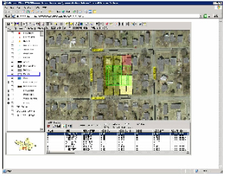 three other counties over a 500-sqaure mile area. It presents some challenges for GIS planning but GTG was very knowledgeable in that area so we were confident they could meet our needs.” Because Pollock is the only person in the IT department that handles GIS, getting an intranet solution was a top priority.
“GTG sent GISmo™ as a trial, and it went really well. But we needed a more widespread distribution, so David Holdstock suggested we serve as a beta site for GISmoWeb™was just being developed. Within a year, we had more than 100 PCs using GISmoWeb. Some people use it once a month, some use it every day, but everyone loves it. We could put it on 50 more PCs today.”
GISmo™ is a desktop application that is based on ESRI’s MapObjects™ technology. The user friendly interface allows users to dynamically configure, map and analyze existing GIS data. GISmo gives users the ability to view, search, query and browse their GIS data quickly and easily.
GISmoWeb™ works much like GISmo, except its installation is performed through Microsoft Internet Explorer. This leads to significantly less maintenance when dealing with new users or performing upgrades. The entire GISmoWeb application can be downloaded simply by accessing a URL.
Pollock said GISmoWeb’s simplicity has been key to its acceptance. “Training takes 90 minutes, max. If a person can use a mouse and open an application, they can do it.” GISmoWeb has also been a way for the city to give users with slower Internet connections access to GIS.
“We don’t have ideal computing situations for everyone, so this  has been a creative way for us to do more with less,” she said. Danville’s public safety departments installed GTG’s LookingGlass Crimes and LGdispatch to use with their HTE™ Computer Aided Dispatch program.
“The public safety people are very happy. They are always thinking of additional functions they want,” Pollock said.
Other departments using GISmoWeb include Community Development, Utilities, the Fire Department, and the Public Works Department.
Community Development workers use the information for inspections, planning work projects, and for providing maps and data directly to citizens. “They have two terminals they use to show citizens maps of areas they may be thinking of purchasing, or asking for building permits on. They can easily see property lines, building footprints, zoning information and where they can and cannot develop. We can also print maps for people to take into the field. It's great to be able to respond to requests so quickly,” Pollock said.
The city manager also is a frequent GISmoWeb user. He likes to see areas that are the subject of complaints or neighborhood disputes.
“If a tree falls on someone’s property, he can pull up the aerial photograph of the area and see exactly what the citizens are describing,” she said. Utilities officials can see where meters, power lines and utility poles are located. “All of the infrastructure for water, gas, electric and sewer are right there on the maps,” Pollock said.
“One of the nice things about GISmoWeb is that we can configure it differently for each department. The Utilities Department doesn’t need all of the zoning information, and Public Works has between 50 and 100 data layers, so it’s important they don’t have information that they don’t need. It simplifies it for the users,” she said.
“I know we are still not there completely, but every day someone discovers a new use for GIS, and they’re hooked. Soon, I think people will realize just how important it is for every facet of our jobs.”
Contact: Geographic Technologies Group, Inc. • 648 North Spence Avenue • Goldsboro, NC 27534 • Phone: 1.888.759.4222 • Fax: 919.759.0410 • E-mail: info@geotg.com


