
Follow
Blog: Chris Harlow on ITISSN 0742-468X
Since 1978
On-line Since
Y2K
Search The Harlow Report Archives

Custom Search
menu
Archived GIS Snippets
Published in 2015
Permanent URL
ArcGIS Book: 10 Big Ideas about Applying Geography to Your World
 The ArcGIS Book is an easy-to-comprehend guide to 10 big web mapping ideas and how to use the ArcGIS platform to put those ideas into action.
People around the world are discovering that online maps do more than direct consumers to arcgis.comstores or help travelers navigate from point A to point B. Web maps communicate important information that helps everyone make decisions. That's why Esri has published The ArcGIS Book: 10 Big Ideas about Applying Geography to Your World, an easy-to-comprehend guide to 10 big web mapping ideas and how to use the ArcGIS platform, Esri's geographic information system (GIS) technology, to put those ideas into action.
ArcGIS is a complete system for discovering, creating, consuming, and sharing geographic data, maps, and apps that fully operates on the web and mobile devices. "At Esri, we recognize that the web, cloud computing, smartphones, and tablets have forever transformed how GIS technology is applied," said Clint Brown, director of product engineering at Esri. "In response, ArcGIS has become a web GIS platform. We wanted to publish a book that not only describes how these trends have transformed GIS but also teaches people how to use the system."
Among the 10 big ideas covered in The ArcGIS Book are the online mapping revolution and its role in GIS; storytelling with maps; mapping in 3D; the social implications of web GIS; the power of spatially intelligent apps; and the emergence of mobile GIS on smartphones with, as the book says, "a live data sensor in your pocket."
In an interesting way and with interactive components, the book takes readers on a journey on how to create and share GIS web maps, use new smart mapping capabilities in ArcGIS to make beautiful and well-designed maps, do spatial analysis online, make 3D web scenes, work with mobile GIS, and do much more.
Each chapter also includes an ArcGIS Lesson that readers can access online. They can put what they learn to work using Esri-provided data and ArcGIS and get hands-on experience in all aspects of web GIS, including crafting a Story Map, solving problems with spatial analysis, editing geographic data, and building a 3D model. The book also inspires the enthusiastic and visionary mapper, providing links to hundreds of live examples of web maps and apps and videos of thought leaders describing some of the trends driving the industry.
TheArcGISBook.com hosts the Learn ArcGIS lessons and other supporting materials. "There is no better way to learn than by doing," Brown said.
Interspersed throughout The ArcGIS Book are short essays by thought leaders such as Esri president Jack Dangermond and Allen Carroll, program manager, storytelling for Esri, and the former chief cartographer at National Geographic.
The ArcGIS Book was written for a diverse audience, including GIS professionals just venturing into the new world of web GIS as well as web technologists, information workers, web designers, and others who increasingly recognize how maps play a pivotal role today in clearly communicating information. The book also serves as a perfect introduction to web GIS for managers and executives interested in understanding how maps can help them make sound business decisions for their organizations.
The ArcGIS Book was edited by Christian Harder, a writer at Esri and the author of several books about GIS including Understanding GIS: An ArcGIS Project Workbook,Second Edition, published in 2013 by Esri Press.
first published week of: 07/20/2015
Permanent URL
ArcGIS Runtime SDK 10.2.5 for Android is here!
by eric bader
The 10.2.5 release of the ArcGIS Runtime SDK for Android has arrived, and we are very excited to share the work that’s been done to modernize and enhance the professional development experience for ArcGIS Android developers.
As you may have heard already, Google released its Android Studio 1.0 this past week, and the ArcGIS Runtime SDK development team stayed on top of it, providing full API and SDK integration for Android Studio and the Gradle build framework just 10 days after Google’s release announcement!
These enhancement and innovations in the 10.2.5 SDK are in lock-step with the direction that Google is guiding their platform developers toward; more support for Android Studio tooling and the Gradle build system. Developers will see less and less emphasis on Eclipse and Ant from Google for Android development as time goes on, and the ArcGIS Runtime SDK for Android will continue to reflect this direction. This release, in fact, will not include the previously-available Eclipse plugin.
Get started today with The ArcGIS Runtime API in Android Studio, and check out the new Gradle-based sample projects for Android Studio, available in Github.
first published week of: 01/05/2015
Permanent URL
ArcPad 10.2.2 Released
by chris leSueur
The ArcPad team announceed that ArcPad 10.2.2 is available to download via the My Esri website. The ArcPad 10.2.2 update addresses some important usability and feature enhancements that improves the utility and stability of ArcPad. Here are some highlights:
Updated Projection Support
The projections and datums libraries in ArcPad have been updated to match ArcGIS Desktop 10.3. To help guide users who need to implement custom or unique local projections the documentation for supported projections and supported datums has been expanded.
Working with Photos
It has become more and more common for ArcPad users to collect photos in the field to accompany geographic and attribute data. Now users who check-out and check-in data via Toolbox tools, scripting or the Data Manager object model have better control when working with photos. Photos can be associated with multiple feature classes and the import folder location can be specified. See the expanded help topic for the ArcPad Check Out tool for more information on working with photos. continued…
first published week of: 02/02/2015
Permanent URL
Are Map Legends Too Lazy?
by alasdair rae
A somewhat click-baity blog title, but I wanted to crowdsource some knowledge from proper carto/viz people, so if you have any insights on what I write, please feel free to get in touch via twitter or e-mail. No doubt what I write about below already has a name but I don't know what that is and I haven't seen this functionality in proprietary or open source GIS. By asking 'are map legends too lazy', what I really mean is are GIS-made choropleth map legends doing enough for us in their current form - and is there an opportunity for us to add some new functionality which enhances the communicative power of the humble choropleth legend? An example... look at the map below, which I created in QGIS. It's a map of a new deprivation* dataset for England, focused on the local authority of Birmingham.
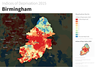 Deprivation choropleth, with legend and inset map
This dataset is typically understood and discussed in terms of deciles, hence the classification used above. The dataset goes from decile 1 (most deprived) to decile 10 (least deprived) - within the context of England as a whole. Cities like Birmingham tend to have a higher proportion of their small areas in the most deprived decile, and in map form this results in lots of red and not much blue, as you can see above. If you wanted to find out how many areas were in decile 1 (most deprived) you would know that it was 'a lot' but because the inner-urban areas tend to be smaller in size (relative to the blue ones), making an accurate assessment visually is quite difficult. In fact, owing to the different sizes of the spatial units, you could quite easily take the wrong message away from a choropleth like this. continued…
first published week of: 10/05/2015
Permanent URL
Attorney General Kamala D. Harris Issues Consumer Alert on Location Services Used by Mobile Apps
California Attorney General Kamala D. Harris today issued a consumer alert on location services used by mobile applications (apps).
With a tap on your smartphone or tablet, you can get a list of nearby restaurants, directions to a friend’s home or a local weather forecast. Location services on your device make a variety of convenient apps work. Location services take your geographic information from satellites (GPS), WiFi and cell-tower networks. What you may not realize is that some apps can access your location all the time, even when you’re not using them. Your location might be “always on.”
Broadcasting your location can sometimes expose you and your family to risk of theft or physical harm. For instance, you may be unknowingly revealing your location if your phone is “geo-tagging” your photos. When you take a photo, the location where it was taken may be inserted into the image file, along with the date/time stamp. If you post the photo online, you are revealing your location at a point in time. Sharing a “selfie” without disabling geo-tagging can be dangerous, especially for victims of stalking or domestic abuse.
How mobile location services work may be technical, but you do not have to be an engineer to have more control. By adjusting the settings on your mobile device, you can control location services to protect your privacy on today’s “always on” frontier.
For more mobile privacy tips, including how to control location information on other mobile platforms, see the California Department of Justice’s information sheets Getting Smart About Smartphones: Tips for Consumers and Getting Smart About Smartphones: Tips for Parents. For tips on safe social networking, see Staying Private in Public: How to Limit Your Exposure on Social Network Sites. All are available online at www.oag.ca.gov/privacy/info-sheets.
first published week of: 01/05/2015
Permanent URL
Best Free GPS Cell Phone Locator Services
Being able to track the movements of a person or a car on a satellite map, bugged with a transreceiver, was stuff you watched in spy movies. Today, GPS tracking devices are available that can actually trace your location anywhere on Earth. Even cell phones are now enabled with GPS tracking and their location can be tracked on an online interface, with detailed maps.
Now there are several free GPS cell phone locator software programs, made available online, which you can install on your phone, to track its location and make it visible to your close friends and family members.
About Free GPS Cell Phone Search
When facilities for tracking cell phones online for free, pop up on the Internet, some people raised concerns about it being used for nefarious purposes. However, a close study of such online services will reveal, that adequate security measures have been taken to prevent any such thing from happening. Once the software is installed on a cell phone, the location can be tracked online, only after entering a login name and password.
Unless the login name and password is hacked, there is no reason to worry about the free cell phone tracking software account falling into the hands of anybody else. Take care to use secure terminals when logging in to view mobile phone location and use a complicated alphanumeric password, which makes it harder to hack. continued…
first published week of: 09/07/2015
 ♦
♦ 