
Follow
Blog: Chris Harlow on ITISSN 0742-468X
Since 1978
On-line Since
Y2K
Search The Harlow Report Archives

Custom Search
menu
Archived GIS Snippets
Published in 2015
Permanent URL
Apple quietly acquires Coherent Navigation for precision GPS mapping
by Lindsey Caldwell
Apple could be looking to bolster its mapping services; which have a bit of a spotted history, polarizing iPhone users. Apple just purchased the company Coherent Navigation which specializes in High Integrity GPS. This specialized GPS system differences from consumer-end GPS systems in that it uses data from multiple Iridium satellite networks to give incredibly precise locations--accurate within centimeters. Apple is keeping mum on the deal, confirming the deal with a standard, boilerplate response, "Apple buys smaller technology companies from time to time, and we generally do not discuss our purpose or plans."
Although Coherent's previous specialty is well-known, it's unclear exactly what plans to do through this new acquisition. According to MacRumors which first reported the acquisition, at least some of Coherent's employees have recently made the move to Apple, so the acquisition could be for talent as well as their proprietary technology.
Previous incarnations of Apple Maps left something to be desired. Its iOS 6 version had such egregious errors that a misplaced Australian city in Apple Maps sent drivers deep into a national park, needing to be rescued from the desert.
CEO Tim Cook even went so far as to pen an apology letter to Apple fans after its iPhone maps disappointed customers, back in 2012. continued…
first published week of: 05/18/2015
Permanent URL
Apple Researching Geofencing Tech That Could Make Errands Easier
by darrell etherington
Apple has a new patent application (via AppleInsider) that could make it easier to manage shared household tasks like picking up groceries or remembering to grab a bottle of wine on the way home. The patent request describes a way in which one user can grant access to their location data to another, sort of like how they currently can in Find My Friends, but with additional features that can send an alert to the person granted access when the first user does things like land within range of a grocery store.
The feature would allow for customized location notifications based on their movement through preset geofenced locales, meaning you’d get notifications on your device when the person sharing their location with you moves near certain landmarks, not just when they leave or arrive at a set destination, as is currently possible in Find My Friends. The device would offer a custom notification about the event depending on what kind of location it is, and you could then respond to that notice by sending a custom message to the user in motion, potentially with a route included to a new destination if you want them to, for instance, stop off at that nearby store for milk.
The interface included in the application allows you to specify time from a point of interest, and the broad category of POI to receive a notification. One you send that request to the person whose location you’re seeing, if they accept it, they’ll automatically receive a re-routed navigation option on their own device (presumably in Maps). You can imagine how handy this might be given further reach of CarPlay, for instance. continued…
first published week of: 06/29/2015
Permanent URL
Apple Wins Patent for 3D Animated Maps that could be manipulated via Touch, Perhaps 3D Touch
by jack purcher
In 2013 Apple went 3D maps crazy. In one report alone we listed 28 different patent applications. The one patent that wasn't listed in that group has been granted a patent today under the title non-static 3D Map Views. Now that Apple has introduced 3D Touch with the new iPhone 6s, we can easily see how Apple may be able to apply the animated aspect of maps via touch that makes sense.
Apple has been granted a patent for their invention that provides a novel mapping application that animates three-dimensional (3D) views of a map when the mapping application renders the 3D views while in a satellite viewing mode. In some embodiments, the mapping application renders the 3D views of the map using camera captured images (CCIs) when the mapping application is in the satellite viewing mode.
The mapping application of some embodiments animates different defined types of map elements and/or constructs (e.g., bodies of water, shorelines, buildings, foliage, etc.) in the 3D view of the map. The mapping application of some embodiments animates some or all of the different defined types of map elements and/or constructs differently. For instance, in some embodiments, the mapping application animates bodies of water and buildings differently by using different shaders for rendering the bodies of water and the buildings. continued…
first published week of: 10/05/2015
Permanent URL
Apple’s survey app helps venues easily create indoor maps
by james vincent
Apple has quietly launched a dedicated indoor positioning app on iOS, letting business owners map out their venues using just their iPhones. The Indoor Survey App was first spotted on the App Store by developer Steve Troughton-Smith, and although it doesn't appear in search, it's easily accessible via a direct link.
"Enable indoor positioning within a venue using the Indoor Survey App," reads the description on iTunes. "By dropping 'points' on a map within the Survey App, you indicate your position within the venue as you walk through. As you do so, the Indoor Survey App measures the radio frequency (RF) signal data and combines it with an iPhone's sensor data." continued…
first published week of: 11/02/2015
Permanent URL
ArcGIS 10.3 Now Certified OGC Compliant
As part of Esri's ongoing support of GIS interoperability, the latest ArcGIS 10.3 release is now certified as Open Geospatial Consortium, Inc. (OGC), compliant.
This certification from OGC reaffirms Esri’s continued commitment to standards-based interoperability. Through its support for OGC specifications, ArcGIS users can access data and services from many different sources, regardless of the technology used by those sources. In addition, users can share their content with others, including non-Esri users, thus contributing to the larger goals of the open data movement.
"Our goal is to help our users be successful, and Esri sees technical interoperability as a key driver to successful implementations," said Dr. Satish Sankaran, Esri product manager for interoperability and member of the OGC Architecture Board.
The OGC leads the development of geospatial interoperability standards. Esri is a long-standing, active OGC participant, helping GIS users to seamlessly work together.
Esri's first OGC compliancy certificates were granted in 1999, and many more Esri ArcGIS platform products have met OGC compliancy since then.
See the full list of OGC-compliant products from Esri.
first published week of: 02/02/2015
Permanent URL
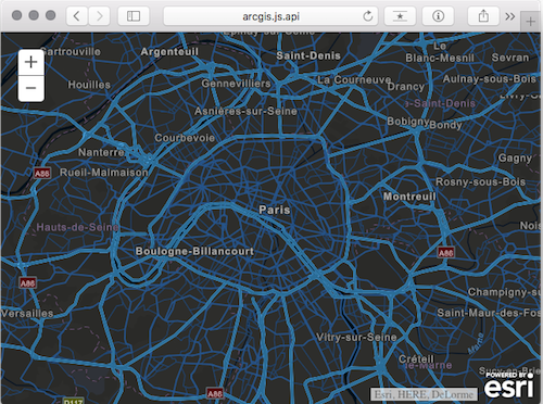
ArcGIS API for JavaScript Version 3.15 Released
by Lloyd Heberlie, Björn Svensson, and Kristian Ekenes
Version 3.15 of the ArcGIS API for JavaScript introduces vector tiles, better maps through predominance renderers, legend improvements, and many other bug fixes and API enhancements. GeometryEngine and FeatureTable also are no longer beta.
Vector tiles
Vector tiles display cached data similar to image tiles, except they store a vector representation of the data. Client-side drawing of vector tiles allows for customizing the styles of the layer and its sublayers which can drive dynamic, interactive cartography. For more information see the VectorTileLayer documentation in the API Reference and the Vector tile layers topic in the ArcGIS Online Help.
Click the image below to view a sample of a world street map vector tile layer with a predefined “night” style applied to the layer.
first published week of: 12/07/2015
 ♦
♦ 