
Follow
Blog: Chris Harlow on ITISSN 0742-468X
Since 1978
On-line Since
Y2K
Search The Harlow Report Archives

Custom Search
menu
Archived GIS Snippets
Published in 2015
Permanent URL
Washington Suburban Sanitary Commission Enhances Customer Service with Esri Enterprise System
Nearly two million people stand to benefit from significant technological improvements made by Washington Suburban Sanitary Commission (WSSC), one of the largest water and wastewater utilities in the country.
WSSC, serving Prince George's and Montgomery counties in Maryland, recently signed an enterprise license agreement (ELA) with Esri to expand its access to ArcGIS, an advanced mapping technology. The increased use of geographic information will enhance WSSC's customer service through more efficient time and resource management.
"GIS will provide our field crews with geographic intelligence, such as location awareness, real-time traffic information, location information on buried assets, and routing information," GIS Analyst Ashwani Singh said. Singh helped lead the project.
An advanced mobile workforce management system is set to replace WSSC's current paper-based fieldwork system. The move from paper to digital will enable field crews and the central office to exchange real-time updates.
The old way had field crews receiving static job lists. But if the job facts or the priority level changed, the static lists did not, so crews may have acted under old information. With the automated workflow, changes relay immediately to the field on handheld devices.
WSSC is using Esri's mobile and online GIS apps, such as the Collector for ArcGIS app, to eliminate the need for paper forms.
In the future, WSSC will implement ArcGIS GeoEvent Extension for Server. The extension tracks moving and stationary assets, such as vehicle locations and water mains, to dispatch crews more quickly during emergencies.
first published week of: 01/05/2015
Permanent URL
Watch a Decade of Data Come to Life on OpenStreetMap
by laura bliss
OpenStreetMap passed its 10th anniversary last fall. Over those years, it's led a quiet revolution in digital mapmaking.
Using GPS tools, satellite photographs, and their own local knowledge, citizen cartographers the world over have used the open-source platform to map the world little by little, creating a free, nimble alternative to geographic data from Google, Microsoft, and the like. In many ways, OSM represents a democratization of cartography, a field long closed off to non-experts.
To mark the decade gone by, Mapbox has created a remarkable interactive that shows years of crowd-sourced geographic data—streets, buildings, natural features, points of interest—coming to life across the globe. In gorgeous technicolor, you can "jump" from city to city, or move around the world as you please. Some regions light up gradually, representing regular additions of data over time, while others are slow for years before suddenly bursting with data.
To mark the decade gone by, Mapbox has created a remarkable interactive that shows years of crowd-sourced geographic data—streets, buildings, natural features, points of interest— coming to life across the globe. In gorgeous technicolor, you can "jump" from city to city, or move around the world as you please. Some regions light up gradually, representing regular additions of data over time, while others are slow for years before suddenly bursting with data. You can see it here.
While OSM's wide field of mapmakers has its drawbacks, it's also got huge advantages. Because it's so readily adaptable, OSM has become a go-to resource during humanitarian crises and natural disasters. continued…
first published week of: 03/23/2015
Permanent URL
Waze Remains Top Navigation App With Big Update
by brett molina
That road trip is about to look a lot different if you’re a fan of the popular navigation app Waze.
The GPS app that blends crowdsourced social updates from its users received a major upgrade, featuring a redesigned user interface making it easier to share updates, but still leaving the screen a bit cluttered.
Founded in 2007, Waze surged in popularity on the iPhone and Android smartphones as a GPS app with a significant social component. The company was hot enough to attract Google, which bought Waze in 2013 for more than $1 billion.
Waze works as your standard navigation app, with a social twist: You pop in your destination and Waze takes you there. Users can save Favorites such as their home or work to jump-start navigation, and even share where you’re going and estimated arrival time with friends. continued…
first published week of: 10/26/2015
Permanent URL
Waze Sued For Allegedly Stealing Map Data
by robert baldwin
Google and its mapping service Waze are being dragged to court over allegations that Waze stole data from a rival's map database. The lawsuit filed in San Francisco federal court on Tuesday by PhantomAlert alleges that the navigation app used proprietary data from PhantomAlert without permission. Both apps share road, red light and traffic information. According to PhantomAlert CEO Joseph Seyoum he noticed that Waze was using the same fictitious location information in its app that his company had used to test PhantomAlert. The only way Waze would have that fake location data is if it was using information from Seyoum's company.
In a statement Seyoum said, "I started PhantomAlert seven years ago as an entrepreneur with a dream, and now that dream has been crushed by companies that are profiting from the years of blood, sweat and tears our team put into our product." continued…
first published week of: 09/07/2015
Permanent URL
Web GIS: A Mission-Critical Technology for Emergency Management
by bob greenberg, founder and ceo, g&h international services
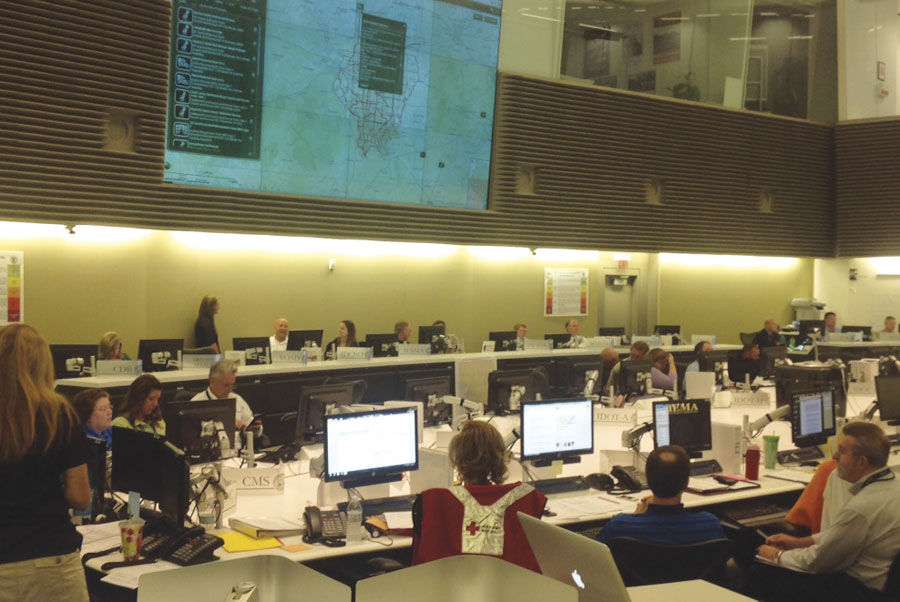 A dashboard at the Illinois Emergency Management Agency shows the status of Mission Ready Packages and Essential Elements of Information for preparedness and response.
www.esri.com/esri-news/arcnews
For years, GIS has been an important tool for improving situational awareness, especially in emergency preparedness and response. During a crisis, having a clear, real-time understanding of the situation as it unfolds is critical for making decisions that help save lives. The challenge for decision makers has always been to acquire and analyze meaningful information so they can make timely and informed decisions. GIS—with its capacity to mash up and visualize multiple datasets in a single platform—makes it easier to identify the data you need to make those decisions.
The advantages of GIS were demonstrated time and again during projects carried out as part of the Department of Homeland Security Science and Technology Directorate's Virtual USA (vUSA) initiative. Launched in 2009, it was designed to establish and demonstrate best practices for situational awareness. An important part of the success of that program—which, to date, has engaged more than 30 states, hundreds of cities and counties, and various federal agencies—has been the use of GIS to create situational awareness platforms, or "viewers," and applications that provide emergency management personnel with real-time information visualization so they can make better use of the data at hand.
To a certain extent, the vUSA program accounts for the increasingly widespread use of GIS across the homeland security enterprise over the last five to seven years. But the role and importance of GIS have dramatically changed.
Within the last year, GIS has become a foundational, mission-critical technology for homeland security and emergency preparedness and response missions. The creation of the web map format, coupled with the deployment of web GIS, was a game changer. Now, homeland security and emergency management professionals have unprecedented capabilities to obtain, share, make sense of, and use information in increasingly more effective ways. continued…
first published week of: 11/23/2015
Permanent URL
What will happen if Google and Microsoft leave the mapping world?
by Chloe Green
With Google and Microsoft dropping emphasis on the burgeoning geospatial market, who will take on the mantel?
Microsoft and Google are getting out of the mapping game. That is the view of many, but the main thrust of their recent moves is to ditch their desktop and server products, while retaining and building upon their advertisement driven mapping models. Google Maps and Google Earth will remain, but even the future of the flagship desktop Google Earth is uncertain, with no new features for two years coupled with the departure of Brian McClendon and the conversion to freeware of Goggle Earth Pro.
For map software customers this sudden shift in product focus emphasizes how unreliable it is to invest in geospatial technology from companies, no matter how big, that aren’t fully committed to Geographic Information Systems (or GIS, the geek terminology for mapping applications.) GIS enables individuals and organizations to make better decisions, save money, and improve the world. Really. Understanding and optimization are key to growing an organization or to deep-dive into complex issues that have local, regional or global impacts. Place and space are fundamental to human activity and natural environments, and GIS is ideally suited to help people better explore these systems continued…
first published week of: 03/16/2015
 ♦
♦ 