
Follow
Blog: Chris Harlow on ITISSN 0742-468X
Since 1978
On-line Since
Y2K
Search The Harlow Report Archives

Custom Search
menu
Archived GIS Snippets
Published in 2017
Permanent URL
Use Web AppBuilder to create configurable app templates
by bern szukalski
Once you’ve authored a map, you can complete the user experience by creating a web app. You can create a web app by choosing from a pre-established collection of configurable app templates, or using Web AppBuilder to create a custom app using a library of configurable widgets.
You can customize the collection of configurable app templates, and the easiest way to create them is using Web AppBuilder. Follow this discussion to learn how.
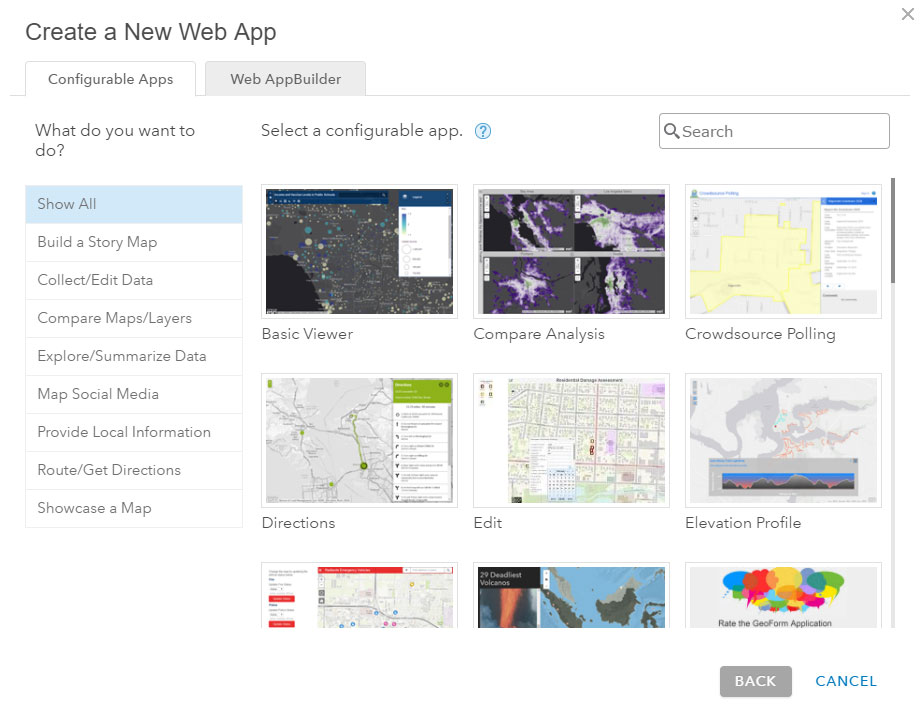
About Create a New Web App gallery
When you save and share a web map, click Create A Web App.

This displays the current gallery of configurable apps. The default collection of configurable apps is authored and hosted by Esri.
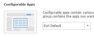
Configurable apps and your organization
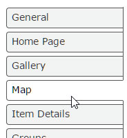
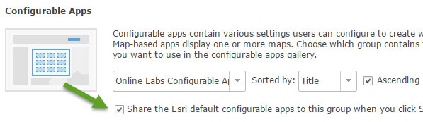
One of the organization settings that can be applied by an Administrator is which apps appear in the Configurable Apps gallery. From the Administrator home page, click My Organization, then Edit Settings, and click Map to view the current settings.
By default, the Esri Default apps are displayed.
You can use other configurable apps by creating a group, adding the configurable apps you’ve created to the group, then choosing the group from the dropdown list. Below Online Labs Custom App Templates is the name of the group containing the custom configurable apps we want to use in our organization.
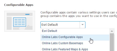
Note that you can replace, or include, the Esri default apps by checking the box.
Use Web AppBuilder to create configurable apps
Using Web AppBuilder you can easily create configurable app templates for your organization by exporting 2D or 3D apps. Your template will be hosted in your portal; either in ArcGIS Online or Portal for ArcGIS. To create a configurable app using Web AppBuilder follow these steps: Read full story at blogs.esri.com/esri/…
first published week of: 04/24/2017
Permanent URL
What’s Coming in the (esri) Business Analyst Web App
by praveen srivastava
The upcoming update of the Business Analyst web app is planned for the end of February and will include several improvements and enhancements. Here is what we have planned:
- More Powerful Suitability Analysis
- Improved infographics with Support for Location Attributes and Your Own Data
- Bring in Your Own Data More Easily and Use Them in Reports
- Latest Demographic Updates for 32 countries in Western and Eastern Europe
first published week of: 02/13/2017
Permanent URL
Who's Afraid Of Location Data?
by offer yehuda
With most brands now adopting mobile, it’s become essential to use location data to more effectively connect with customers. Location data doesn’t simply indicate where users are. It can be used to provide insights about audience segments and their preferences.
Mobile advertisers are willing to pay a premium for location data because of the value it brings. Five publishers that tracked online ad traffic for over a full year discovered an increase of 19% in eCPMs for requests that included GPS data, compared with those who originated from IP addresses. This higher value was derived not only from the ability to serve users relevant ads for their locations, but also from the ability to map users’ behavior and activities.
Users sometimes resist the fact that location data is being used to track consumer behavior. But there is a great deal of hypocrisy related to location data. On one hand, users complain that their privacy is violated — yet they share their personal data freely when using their favorite mobile apps. In fact, nine in 10 U.S. smartphone owners use location services on their phone, according to data from Pew Research Center.
Here are five of the most common ways consumers benefit from location based services. continued…
first published week of: 02/27/2017
Permanent URL
Why Location Strategy Matters for Utilities
by bill mehan
We have a burglar who visits our house regularly. Unlike most burglars, he or she only steals small, mostly unimportant items. Aside from an occasional sock, the stolen goods are almost always tools that I use around the house. I know they are being stolen, since I always remember exactly where I have put a tool once I’m done using it. Then, when I go to use that tool again, it’s gone—stolen. It’s not the value of the tool that is important to me; it’s the time I waste looking everywhere in vain for it. The funny part is that the burglar always returns the stolen items (except for the unmatched sock). The interesting part is that he or she puts the items in a completely different location from where I leave them.
This same thing often happened at the utility company where I used to work. Our crews would carefully and precisely document the location of every piece of equipment that they installed. Yet during a power failure or a project, the equipment—like a transformer, a valve, or a switch—would be mysteriously stolen at some point and returned to a different location. And like my experience at home, the crews would waste precious time looking for the equipment that was supposed to be in one location but was somewhere else. This was especially frustrating in the case of underground cables. Someone apparently was digging up the cables and moving them sometimes 10 feet or more. And during a power failure, customers would have to wait longer for their power to be restored because of the utility’s lack of knowledge of where things were. Finally, this lack of precise location information created safety issues. This reminds me of the time that the burglar at my house returned my box knife. He or she placed it, with the blade exposed, into a box reserved for cleaning rags. I stuck my hand into the box and cut myself—all because of a lack of information about where.
Clearly, the above stories are told, tongue placed firmly in cheek. What they illustrate, however, is that the simple task of clearly documenting where something is can be a challenge, certainly for me at home and for companies with a large infrastructure. Read full story at blogs.esri.com…
first published week of: 05/08/2017
Permanent URL
Why Should We Talk About Radar Data?
by derrold holcomb
Over the past several years, there has been a lot of talk about radar data. New sensors, new programs, new software. But the industry hasn’t seen the explosive use of radar data as projected. Why? In part, this might be because the average geospatial professional – even an astute and learned professional – thinks of radar data as existing exclusively in the domain of research, the military, and radar experts.
For a long time, this has been the case. But recently, the use of radar data has been making the transition from pure research to a more operational focus. With the launch of the new generation of radar sensors like TerraSAR-X, Sentinel, Radarsat-2, Cosmo SkyMed, and a whole host of others, the industry has made great strides in making the data more accessible through user-friendly interfaces and workflows.
And yet, there is still a reluctance to use radar data. I think that a lot of this reluctance stems simply from a misunderstanding of the data. To be sure, radar imagery is not a substitute for optical data; the information it makes available is totally different. There is also some disillusionment because the applications for radar data have been both oversold and undersold, leading to a lot of misunderstanding, disappointment and missed opportunities.
How Has Radar Data Been Oversold?
For years, people have touted radar’s ability for surface penetration. It is true that, under very specific circumstances, the radar beam will penetrate the earth or vegetation for several meters. When this works it is a very powerful capability, but… it only works under very specific circumstances.
I have been asked to search for Genghis Khan’s tomb in the mountains of Mongolia, subterranean chambers in Petra, bin Laden in Afghanistan, land mines all over the world, Attila’s horde in the Danube river, oil pipelines in the Middle east, narco-trafficantes in the jungle and numerous other projects. Some worked; most did not. continued…
first published week of: 02/27/2017
 ♦
♦ 