
Warning: session_start(): Cannot send session cookie - headers already sent by (output started at C:\domains\STP100152\theharlowreport.com\wwwroot\2013\article_2013.php:118) in C:\domains\STP100152\theharlowreport.com\wwwroot\2013\article_2013.php on line 202
Warning: session_start(): Cannot send session cache limiter - headers already sent (output started at C:\domains\STP100152\theharlowreport.com\wwwroot\2013\article_2013.php:118) in C:\domains\STP100152\theharlowreport.com\wwwroot\2013\article_2013.php on line 202
first published week of: 02/04/2013
Coastline Paradox
by natgeosean
blog.education.nationalgeographic.com
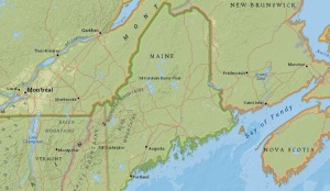
the u.s. state of maine, as seen in the
national geographic mapmaker interactive.
Did you know that the coast of the U.S. state of Maine is longer than the coast of California? It is, depending on how you measure it. Measuring a coastline, it turns out, is a complicated matter and can have varying results depending on the method and tools used.
Take a look at the coastlines of British Columbia in Canada, Alaska in the United States or Norway in northern Europe. The coastline in these places curves inward and outward everywhere, extrudes into the ocean, become discontinuous at water inlets, and zigzags continuously. It is dotted with bays, coves, and the little inlets that rivers and streams empty into and islands off the coast?
When we measure the coastline, do we also include all of these geographic features as part of it? The coastline of the state of Maine is only about 370 kilometers (230 miles) from one end to another. However, when measured taking into consideration its irregularities such as inlets and offshore islands, its length increases to more than 5,542 kilometers (3,450 miles)! It comes to no surprise then that it is counterintuitively difficult to measure the exact length of a coastline. continued…

Volume 35
GIS News Snippets Industry Notes ArchivesSubscribe-Free
Add Your Link
Register 'ur URL
Featured Articles
View Today's Cartoon
GIS Books
Can’t Navigate Out of a Paper Bag
SharePoint Integration Solution Services
Will You Get Advantages From The New Easy To Get SQL Server Professional Certification?
Titusville, FL GIS Case Study
Trade Show Exhibitors:
Tips For Newbies
Can’t Navigate Out of a Paper Bag
SharePoint Integration Solution Services
Will You Get Advantages From The New Easy To Get SQL Server Professional Certification?
Titusville, FL GIS Case Study
Trade Show Exhibitors:
Tips For Newbies

More Articles Contact GIS Supplier Links
About

Custom Search

Save 10%
Use Code STASH

 ♦
♦ 
- Nike Air Max Flyknit
- Nike Lebron 14 Shoes
- Nike Air Force donna
- Nike Roshe Run EN Ligne
- Ultra Boost 2.0 Till salu
- Scarpe da calcio Nike Mercurial Superfly V
- Supra Bleeker Venta
- Nike Huarache Baratas
- Nike Mercurial focicipok
- NIKE SF AF1 DEUTSCHLAND SPEICHER
- Nike Roshe Two iD
- Adidas férfiak nok kivezetés Üzlet
- Nike Dunk Sky Hi Schuhe
- Chaussures de football
- Nike Kobe A.D. 12 Pris
- ZAPATILLAS NIKE AIR MAX 2015
- Nike Dunk Sky High Eladó
- CESTA AIR JORDAN 13
- Nike Roshe RUN Laufen
- Nuevas Nike Air VaporMax
- Authenitc Nike Flyknit Air Max 2014
- Nike Sock Dart SP
- Onitsuka Tiger Mexico 66 pas chers
- NIKE AIR MAX 2018
- ADIDAS NMD SHOES R1
- Air Jordan 11 Scarpe
- adidas Kurobe Childrens Shoes
- Nike Air Max Thea SE
- BOOST yeezy 350 V2 Comprar
- Reebok Instapump Fury OG
- ADIDAS SPRINGBLADE PARA HOMBRES
- NIKE INTERNATIONALIST BILLIGA
- Hiteles Lebron James XIV
- Golden Goose Deluxe Brand For Women
- Schweiz Kyrie 3 Herren
- Scarpe New Balance 999
- Scarpe adidas Stan Smith
- Air Jordan 1
- Nike Air Max 2013 Schweiz
- Real MBT M.WALK