
Warning: session_start(): Cannot send session cookie - headers already sent by (output started at C:\domains\STP100152\theharlowreport.com\wwwroot\2013\article_2013.php:118) in C:\domains\STP100152\theharlowreport.com\wwwroot\2013\article_2013.php on line 202
Warning: session_start(): Cannot send session cache limiter - headers already sent (output started at C:\domains\STP100152\theharlowreport.com\wwwroot\2013\article_2013.php:118) in C:\domains\STP100152\theharlowreport.com\wwwroot\2013\article_2013.php on line 202
first published week of: 07/15/2013
Bentley App Brings Geospatial Data to the Field
 Courtesy Bentley Systems
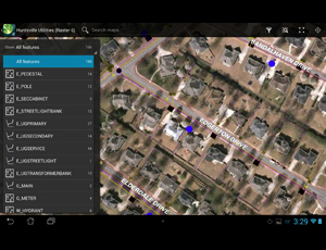
Bentley's Map Mobile displays geospatial data, such as fire hydrants and underwater pipes, overlayed on a map.
Bentley Map Mobile is an app that provides powerful viewing capabilities for Bentley Map users, enabling fast access to very large data sets in the field. Bentley Map Mobile is for field personnel of all types, including inspectors, maintenance crews, and construction personnel. With Bentley Map Mobile, field workers are kept up to date with the latest geospatial data, reducing errors and improving service outcomes.
Bentley Map Mobile supports a simple interface using common gestures such as pinch to zoom, swipe to drag, and touch to select. All feature properties are available for review. Facilities can be quickly located using a free-text search function, and, once found, the selected feature is automatically zoomed to the view. The app is GPS-enabled, which simplifies the location of facilities in the field. If a network connection is available, then an interface to Google Maps will produce directions to the selected facility. The view display can be simplified by toggling features off and on, and a list of features in the current view can be quickly generated for active review.
Bentley Map Mobile requires the use of Bentley Map Mobile Publisher to publish next generation i-models from Bentley Map Enterprise, Bentley Utilities Designer, and Bentley’s communications products continued…

Volume 35
GIS News Snippets Industry Notes ArchivesSubscribe-Free
Add Your Link
Register 'ur URL
Featured Articles
View Today's Cartoon
GIS Books
Can’t Navigate Out of a Paper Bag
SharePoint Integration Solution Services
Will You Get Advantages From The New Easy To Get SQL Server Professional Certification?
Titusville, FL GIS Case Study
Trade Show Exhibitors:
Tips For Newbies
Can’t Navigate Out of a Paper Bag
SharePoint Integration Solution Services
Will You Get Advantages From The New Easy To Get SQL Server Professional Certification?
Titusville, FL GIS Case Study
Trade Show Exhibitors:
Tips For Newbies

More Articles Contact GIS Supplier Links
About

Custom Search

Save 10%
Use Code STASH

 ♦
♦ 
- Nike Air Max Flyknit
- Nike Lebron 14 Shoes
- Nike Air Force donna
- Nike Roshe Run EN Ligne
- Ultra Boost 2.0 Till salu
- Scarpe da calcio Nike Mercurial Superfly V
- Supra Bleeker Venta
- Nike Huarache Baratas
- Nike Mercurial focicipok
- NIKE SF AF1 DEUTSCHLAND SPEICHER
- Nike Roshe Two iD
- Adidas férfiak nok kivezetés Üzlet
- Nike Dunk Sky Hi Schuhe
- Chaussures de football
- Nike Kobe A.D. 12 Pris
- ZAPATILLAS NIKE AIR MAX 2015
- Nike Dunk Sky High Eladó
- CESTA AIR JORDAN 13
- Nike Roshe RUN Laufen
- Nuevas Nike Air VaporMax
- Authenitc Nike Flyknit Air Max 2014
- Nike Sock Dart SP
- Onitsuka Tiger Mexico 66 pas chers
- NIKE AIR MAX 2018
- ADIDAS NMD SHOES R1
- Air Jordan 11 Scarpe
- adidas Kurobe Childrens Shoes
- Nike Air Max Thea SE
- BOOST yeezy 350 V2 Comprar
- Reebok Instapump Fury OG
- ADIDAS SPRINGBLADE PARA HOMBRES
- NIKE INTERNATIONALIST BILLIGA
- Hiteles Lebron James XIV
- Golden Goose Deluxe Brand For Women
- Schweiz Kyrie 3 Herren
- Scarpe New Balance 999
- Scarpe adidas Stan Smith
- Air Jordan 1
- Nike Air Max 2013 Schweiz
- Real MBT M.WALK