
Archived GIS Snippets
Published in 2013
Permanent URL
Avenza Releases Geographic Imager 4.2 for Adobe Photoshop
- new ability to export web tiles compatible with online map services -
Avenza Systems Inc., producers of MAPublisher® cartographic software for Adobe Illustrator® and the popular PDF Maps mobile app, is pleased to announce the release of Geographic Imager 4.2 for Adobe Photoshop. New formats are supported, including writing to the DEM TIFF format which saves raw DEM values and exporting web tiles to Google Maps or Microsoft Bing Maps format. In addition, there are a number of new and exciting product features and enhancements. This release also is also available at the Geographic Imager Basic license level which provides support for the geospatial framework in Adobe Photoshop as well as limited import and export abilities at an introductory price level. Also new in this release is the addition of the Georeference feature with the Geographic Imager Basic license.
“We've been working on some very innovative features lately, one of them being the ability to export web tiles using Geographic Imager from Adobe Photoshop,” said Ted Florence, President of Avenza. “The web tiles are compatible with several online map services which allows our users to spend less time worrying about image referencing and more time creating online mapping solutions,“ he added. “Another great feature in this release is the new ability to save to the DEM TIFF format, which is interoperable and can be reopened in Geographic Imager or in other geospatial software packages. There has been a demand for extended format support and we're continuing to listen to our users’ needs.”
Additional Geographic Imager 4.2 features
- Available Geographic Imager Basic license
- DEM TIFF write support, format saves raw DEM values
- Ability to Export Web Tiles to Google Maps or Microsoft Bing Maps format
- Geographic Imager panel improvements, including new Survey and Ruler tabs
- Crop by Vector File Extents, use the geographic extents of a vector file to crop an image
- Streamlined user interactions with command boxes and simpler messages
- Various bug fixes and user experience enhancements.
first published week of: 05/27/2013
Permanent URL
Avenza Releases MAPublisher 9.2 for Adobe Illustrator
Avenza Systems Inc., producers of the PDF Maps app for iOS and geospatial plugins for Adobe Creative Suite, including Geographic Imager for Adobe Photoshop, released MAPublisher 9.2 for Adobe Illustrator. This exciting release includes a number of new and exciting product enhancements. Export has been improved and streamlined to make it easier to quickly export MAP Views and MAP layers. Also included in this release are several new tools including Automation and Path Utilities.
"We're delighted to release MAPublisher 9.2 which includes improved export functionality and advanced map-making automation,” said Ted Florence, President of Avenza. “Not only can our users create high-quality maps with MAPublisher, they can also use it to increase file interoperability across multiple platforms and overall workflow efficiency,” he added. “We've improved export to geospatial PDF because we are focused on delivering this very popular format to suit the needs in many industries and agencies in all levels of government and to make it easier to produce maps for our mobile PDF Maps platform.”
Enhancements and new features of MAPublisher 9.2
- Streamlined export document to geospatial PDF with clearer indications of how layers and attributes are being handled and exported to appear in Adobe Acrobat.
- Improved MAP View and MAP layer export with multiple layer export supported.
- Export document to image can export a georeferenced image of the entire artboard.
- New Automation tool to configure settings that initiate MAPublisher operations upon data import to automate map production, such as manage MAP Views, apply MAP Theme stylesheets, create grids and graticules, label using MAP LabelPro, and export to geospatial PDF.
- New Path Utilities tool to perform optimization actions on line and area layers.
- New ability to view attributes in a tear-off panel.
- Use the Add Calculated Data function to assign elevation values to existing points.
- Various user interface and performance enhancements to improve usability.
first published week of: 04/01/2013
Permanent URL
Bentley App Brings Geospatial Data to the Field
 Courtesy Bentley Systems
Bentley's Map Mobile displays geospatial data, such as fire hydrants and underwater pipes, overlayed on a map.
Bentley Map Mobile is an app that provides powerful viewing capabilities for Bentley Map users, enabling fast access to very large data sets in the field. Bentley Map Mobile is for field personnel of all types, including inspectors, maintenance crews, and construction personnel. With Bentley Map Mobile, field workers are kept up to date with the latest geospatial data, reducing errors and improving service outcomes.
Bentley Map Mobile supports a simple interface using common gestures such as pinch to zoom, swipe to drag, and touch to select. All feature properties are available for review. Facilities can be quickly located using a free-text search function, and, once found, the selected feature is automatically zoomed to the view. The app is GPS-enabled, which simplifies the location of facilities in the field. If a network connection is available, then an interface to Google Maps will produce directions to the selected facility. The view display can be simplified by toggling features off and on, and a list of features in the current view can be quickly generated for active review.
Bentley Map Mobile requires the use of Bentley Map Mobile Publisher to publish next generation i-models from Bentley Map Enterprise, Bentley Utilities Designer, and Bentley’s communications products continued…
first published week of: 07/15/2013
Permanent URL
Big Winners From Under The Radar? Location Intelligence – Geo-Coded Behavioral Analysis
by brian singh
The notion of remixing and aggregating is at the heart of emerging location intelligence platforms. We have already seen MR firms adapt by having GIS specialists in house. However, have we adapted existing methodologies to the opportunities presented by the mobile universe?
At this session, four companies – GoSpotCheck, Nearbuy, Placed and PlaceIQ presented their offerings of capturing and interpreting geo-specific data. Some were straightforward in replacing or augmenting a service (GoSpotCheck and PlaceIQ) to aggregating data for mining purposes (PlaceIQ) and the detail grabbing of data to deliver better customer offers (Nearbuy and Placed).
The core themes emerging were that the future of location intelligence is mobile driven. And the full functionality of and data available from mobile devices will be explored. There is also the creative aggregation of public and private data sources to yield detailed databases that can be integrated with mobile environments, to yield new forms of normative data, to facilitate insights in decision making. At this same time, there is an emerging “creep” factor – there are lots of data being offered up unknowingly by mobile device wielding consumers and being appended to these databases – the cost of free has an information offering and public profile attached. The research industry must take note of this as emerging platforms continue to keep pushing the envelope of these boundaries.
first published week of: 02/25/2013
Permanent URL
Bing Maps Adds 3D imagery and Skype Integration
by tom keating
Microsoft has redesigned its Bing Maps experience for Windows 8.1 and just posted Bing Maps Preview to the Windows Store, which includes hi-res 3D imagery, from satellite to street view, of our planet. It also includes nifty details like admission prices, payment methods accepted (Amex, Visa, Mastercard), and hours of operation. Think of it as Bing's version of Google Earth, though it currently has only 70 cities available for view in the preview. It also sports Skype integration (enabled via Snapview) so you can click the phone icon and make a Skype call.
With Skype integrated into Xbox One and now Bing Maps, the Skype acquisition is perhaps making a bit more sense. Definite monetization possibilities, especially since "map apps" on laptops, tablets, and especially smart phones (GPS turn-by-turn directions) are one of the most popular. Just look at Waze, which was acquired by Google for $1 billion, and you can see the big boys see maps and geolocation data as the next big thing.
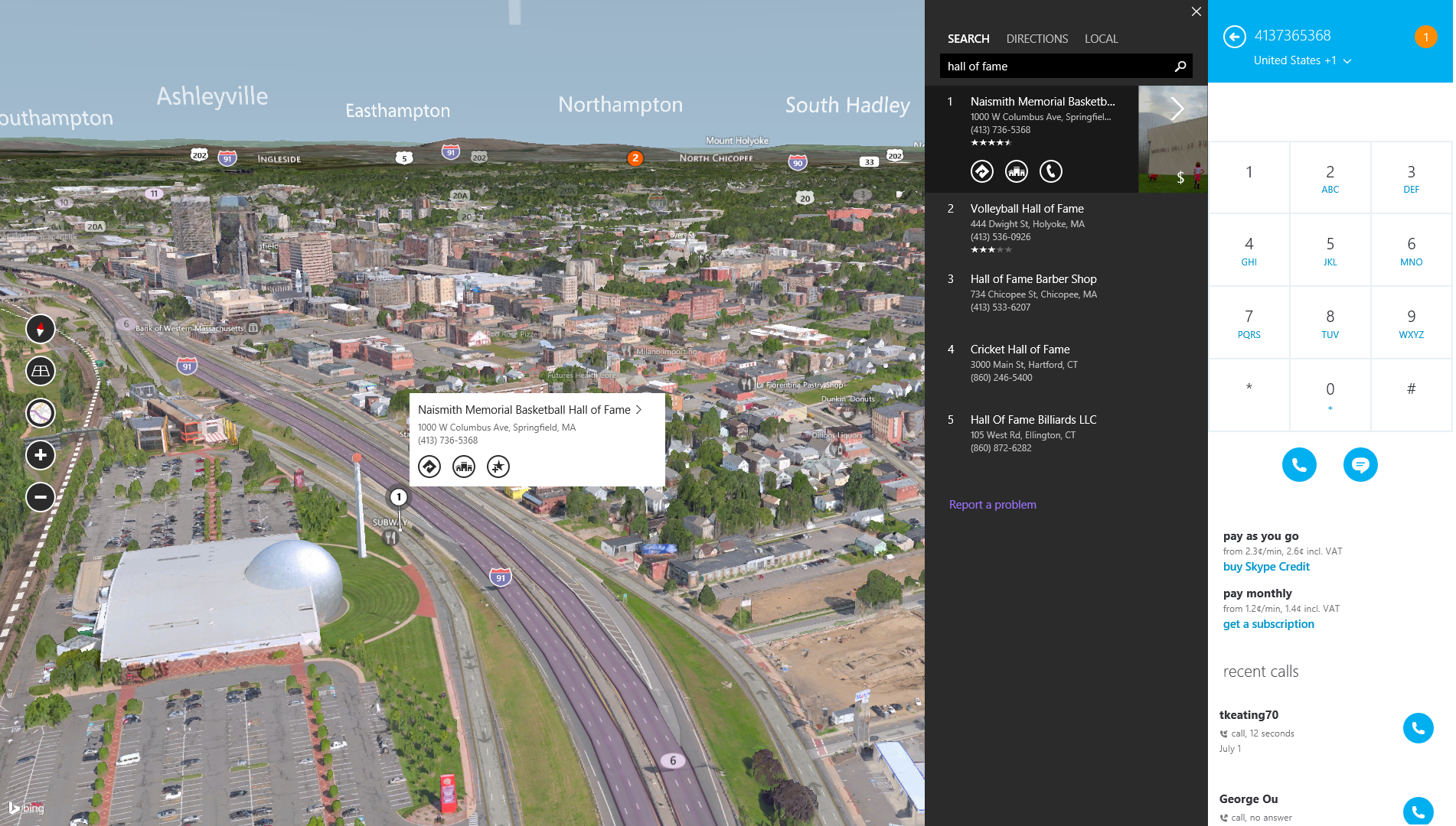
Microsoft touted their new Bing Maps Preview by saying, "We have assembled world builders from the video game industry, expert photogrammetrists, high definition aerial cameras and a massive data pipeline crunching petabytes of imagery to deliver a more natural way to experience our planet. With advances in Windows, in computing hardware and our ability to capture, process and render imagery, our automated pipeline is capable of pushing pixels from a plane to the app in a matter of weeks and has already processed over 121 trillion pixels to date in order to build our 3D environment." continued…
first published week of: 12/09/2013
Permanent URL
Bing Maps in AutoCAD 2014

Bing Maps used in an AutoCAD 2014 design
Did you know that now Bing Maps is the default mapping service in Autodesk’s AutoCAD 2014 software? … Chances are that you use a product or have been in a building, public area or other development that was designed with AutoCAD. AutoCAD and AutoCAD vertical products such as AutoCAD Architecture and AutoCAD Civil 3D, are used in a wide range of industries and by architects, designers and engineers.
How is Bing Maps used in AutoCAD 2014 and the AutoCAD vertical products? AutoCAD now has a built-in geolocation feature and allows users to create and enhance their designs with Bing Maps geocoding and map data. Bing Maps inside AutoCAD 2014 brings in location context and results in more accurate and richer designs.
The key geolocation workflows in AutoCAD 2014 supported with Bing Maps include:
- Locate your AutoCAD design in the real-world using Bing Maps geocoding service
- View your AutoCAD design in the real-world high resolution aerial and satellite imagery
- Aggregate and overlay 2D and 3D geolocated data with your AutoCAD designs
- Locate yourself on your AutoCAD design in the field using GPS and Bing Maps
For more examples, go here
first published week of: 04/08/2013


 ♦
♦ 