
Archived GIS Snippets
Published in 2013
Permanent URL
ArcGIS Announces New Online Plugin for WordPress #MapThis
There’s no question that ArcGIS Online is meant to enable anyone and everyone to access and use geospatial data in many creative ways and when your developing with ArcGIS Explorer the sky is the limit on the kind of map you can create and share with anyone. Now thanks to the GeoJobe GIS Consulting team, you’ll be able to use their new ArcGIS plugin for WordPress. The plugin will be available in a free or pro version and reports to enable users to integrate the power of “where” into their WordPress blog posts – think tens of millions of potential users of your data. Check it out here.
first published week of: 08/19/2013
Permanent URL
ArcGIS API for JavaScript Version 3.3 Released
by derek swingley
Version 3.3 of the ArcGIS API for JavaScript is now available! Please refer to the What’s New in 3.3 document for the full list of features and bug fixes. Highlights include:
- New geocoder widget: Add a geographic search box to your app with a couple of lines of code. The widget defaults to the ArcGIS Online World Geocoding Service but can be customized to use one or more ArcGIS Server geocoding services.
- New map constructor options: The map class has new constructor options that can help you get your map set up using less code.
- ArcGIS.com basemap, such as “streets”, “satellite”, “osm”, etc.
- Array of two coordinates (longitude, latitude) or an esri.geometry.Point.
- Starting zoom level for the map.
- Smallest scale zoom level for the map.
- Largest scale zoom level for the map.
- The map now auto-resizes so it is no longer necessary to set up an event listener for resize events on the map’s container to call map.resize when a map’s container resizes.
first published week of: 01/14/2013
Permanent URL
ArcGIS for Aviation Improves Aeronautical Data Management and Chart Production
Esri eleased ArcGIS for Aviation, a new solution to support users in the aeronautical information management, air navigation service provider, and airport markets. This solution enables users to create, manage, review, and share aviation data. ArcGIS for Aviation includes ArcGIS for Aviation: Charting and ArcGIS for Aviation: Airports. Together, these products provide a comprehensive geospatial platform for aeronautical chart production and airport operations data management.
ArcGIS for Aviation: Charting (previously Esri Aeronautical Solution) improves, standardizes, and increases data and workflow management by allowing standards-based aeronautical data to be captured, maintained, and managed in a centralized database. With it, users can produce standardized and customized electronic and paper aeronautical charts.
ArcGIS for Aviation: Charting provides the ability to do the following:
- Significantly reduce chart production times via automated batch cartographic processing
- Share data within the aeronautical community using the Aeronautical Information Exchange Model (AIXM) standard
- Enhance data quality through direct loading of digital changes and automating change verification
ArcGIS for Aviation: Airports assists airports and their consultants in complying with data management and quality standards such as the Federal Aviation Administration's (FAA) Airport Surveying—GIS program. It provides tools, templates, and analysis functionality that introduce efficiencies and new capabilities into the planning, maintenance, and day-to-day operations of airports.
“GIS is used across all sectors of aviation, but each sector has unique requirements,” says Bruce Frank, Esri’s ArcGIS for Aviation program manager. “ArcGIS for Aviation provides our aeronautical information management and airport customers with an optimized solution for their unique business needs.”
first published week of: 01/21/2013
Permanent URL
ArcGIS Online World Topographic Map first updates for 2013
by arcgis content team
[We] recently deployed a large number of community contributions to the World Topographic Map (World_Topo_Map). These include an additional German State as well as several cities, counties, and districts in the United States and Canada.
Here’s a list of all the contributors; click this link to view a presentation of their work. The presentation uses ArcGIS Explorer, so you can zoom and pan the images.
- Appleton, Wisconsin, United States (1:9k to 1:1k)
- Baden-Württemberg, Germany (1:144k to 1:2k)
- Baltimore, Maryland, United States (1:9k to 1:1k)
- Centennial, Colorado, United States (1:9k to 1:1k)
- Chester County, Pennsylvania, United States (1:9k to 1:1k)
- Des Moines, Iowa, United States (1:9k to 1:1k)
- Des Moines, Washington, United States (1:9k to 1:1k)
- Lawrence, Kansas, United States (1:9k to 1:1k)
- Little Traverse Conservancy, Michigan, United States (1:9k to 1:1k)
- Manatee County, Florida, United States (1:9k to 1:1k)
- Napa County, California, United States (1:9k to 1:1k)
- Olympia, Washington, United States (1:9k to 1:1k)
- Polk County, Wisconsin, United States (1:9k to 1:1k)
- Regional District of Thompson-Nicola, British Columbia, Canada (1:9k to 1:1k)
- Riverside County, California, United States (1:9k to 1:1k)
- Sussex County, New Jersey, United States (1:9k to 1:1k)
- Tift County, Georgia, United States (1:9k to 1:1k)
- Ventura, California, United States (1:9k to 1:1k)
- Waukesha County, Wisconsin, United States (1:9k to 1:1k)
More coming early next month!
first published week of: 01/28/2013
Permanent URL
ArcPad 10.2 Improves Integration with ArcGIS
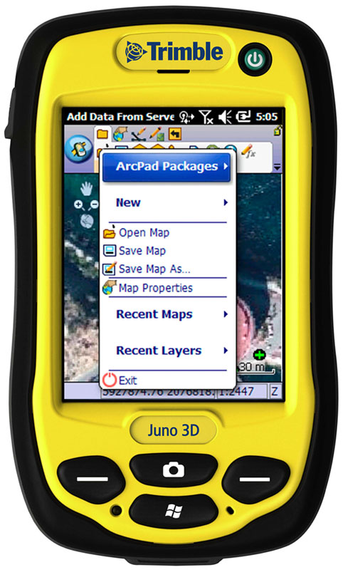 Store ArcPad projects and QuickProject templates on ArcGIS Online for sharing with others.
Continuing its effort to connect desktop and mobile workflows in a seamless platform, Esri has released ArcPad 10.2. ArcPad is mobile mapping and field data collection software designed for GIS professionals. The new version of ArcPad improves synchronization with the ArcGIS platform and speeds data collection in the field with new automation options.
Esri's latest release of ArcPad gives users the ability to directly open ArcGIS feature services in ArcPad and synchronize edits with hosted or on-premises GIS. The new capability significantly improves mobile workflows by enabling disconnected editing of published services. In addition, ArcPad gives users the ability to automate edits with a Quick Fields option, which can be customized to auto-populate any field during data collection.
For users who rely on desktop workflows that revolve around file sharing and distribution, ArcPad 10.2 includes new ArcGIS Online integration. With this option, users can store their ArcPad projects and QuickProject templates as an ArcPad package in their ArcGIS Online accounts for sharing with members of their group. ArcGIS Online subscribers can also browse ArcGIS Online from inside ArcPad with the ability to select and download a project or template, creating an easy, collaborative workflow.
first published week of: 08/19/2013
Permanent URL
Army Corps of Engineers, Muscatine (IA) Area Geographic Information Consortium, and Esri Develop Comprehensive Analysis and Plans
The people of Muscatine, Iowa, enjoy the beauty and the power of the Mississippi River, but they live in fear of floods. It's only a matter of time before devastating floods, like those in 1993 and 2008 in eastern Iowa and 2011 in western Iowa, strike again, according to experts at the University of Iowa's Stanley Hydraulics Lab and the Iowa Department of Natural Resources. To diminish worries and mitigate risks, officials from the City of Muscatine worked with the Army Corps of Engineers, using Esri ArcGIS technology, to create maps of hypothetical levee breach scenarios along the levee system.
"High water is an annual occurrence along the Mississippi River, threatening life, commerce, and agricultural interests," said Randy Hill, public works director for Muscatine. "Proactive planning is an effort to improve emergency response and communication in the event of a catastrophe."
To build the maps the city needed for planning, Mark Yerington, GIS systems analyst for the Muscatine Area Geographic Information Consortium (MAGIC), and Mark Warren, MAGIC GIS manager, worked with ArcGIS Online.
The City of Muscatine Levee Breach Scenarios maps are published online along with the Army Corps of Engineers study presentation.
first published week of: 09/16/2013


 ♦
♦ 